- Practical GIS
- Gábor Farkas
- 277字
- 2021-07-02 22:49:15
Preparing our data
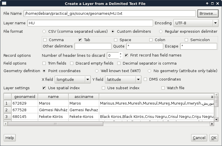
From the currently opened vector layers, the GeoNames layer has the largest attribute table with the most kinds of attributes. However, as the extract does not contain headers, it is quite hard to work with it. Fortunately, CSV files can be edited as regular text files or as spreadsheets. As the first step, let's open the GeoNames file with a text editor and prepend a header line to it. It is tab delimited; therefore, we need to separate the field names with tabs. The field names can be read out from the readme file in order. In the end, we should have a first line looking something like this:
    geonameid name asciiname alternatenames latitude longitude
      featureclass
    featurecode countrycode cc2 admin1 admin2 admin3 admin4 population
      elevation
    dem timezone modification
Now we can remove our GeoNames layer from the layer tree and add it again. In the form, we have to check the option First record has field names. If we do so, and name the latitude and longitude fields accordingly, we can see QGIS automatically filling the X and Y fields:
- 潮流:UI設(shè)計(jì)必修課
- Visual C++實(shí)例精通
- C語言程序設(shè)計(jì)教程(第2版)
- 三維圖形化C++趣味編程
- Java開發(fā)入行真功夫
- 新手學(xué)Visual C# 2008程序設(shè)計(jì)
- 自然語言處理Python進(jìn)階
- 深入淺出Serverless:技術(shù)原理與應(yīng)用實(shí)踐
- 焊接機(jī)器人系統(tǒng)操作、編程與維護(hù)
- Java EE核心技術(shù)與應(yīng)用
- 基于ARM Cortex-M4F內(nèi)核的MSP432 MCU開發(fā)實(shí)踐
- Java EE企業(yè)級(jí)應(yīng)用開發(fā)教程(Spring+Spring MVC+MyBatis)
- Swift語言實(shí)戰(zhàn)晉級(jí)
- 奔跑吧 Linux內(nèi)核
- Visual Basic語言程序設(shè)計(jì)基礎(chǔ)(第3版)