- Internet of Things for Architects
- Perry Lea
- 405字
- 2021-06-25 22:47:02
LiDAR and active sensing systems
This section will cover active sensing systems. We have discussed many passive sensors that simply respond to environmental changes. Active sensing involves broadcasting a signal that is referenced to measure the environment either spatially or sensorily. While this area is broad, we will concentrate on LiDAR as a basis for active sensing systems.
LiDAR stands for Light Detecting and Ranging. This type of sensor measures the distance to a target by measuring a laser pulse reflection on the target. Where a PIR sensor will detect movement within a range, LiDAR is capable of measuring a range. The process was first demonstrated in the 1960s, and is now used pervasively in agriculture, automated and self-driving vehicles, robotics, surveillance, and environmental studies. This type of active sensing machine is also capable of analyzing anything that crosses its path. They are used to analyze gases, atmospheres, cloud formations and compositions, particulates, the speed of moving objects, and so on.
LiDAR is an active sensor technology, and broadcasts laser energy. As a laser hits an object, some of the energy will be reflected back towards the LiDAR emitter. The lasers used are typically in the 600 to 1000 nm wavelength, and are relatively inexpensive. Power is constrained for safety reasons to prevent eye damage. Some LiDAR units operate in the 1550 nm range, as that wavelength cannot be focused by the eye, rendering them harmless even at high energy. LiDAR systems are capable of very long ranging and scanning, even from satellites. The laser will pulse up to 150,000 pulses per second, which can reflect off an object back to a photodiode array. The laser apparatus can also sweep the scene via a rotating mirror to build a comprehensive 3D image of the environment. Each beam that is broadcast represents an angle, Time of Flight (TOF) measurement, and a GPS location. This allows the beams to form a representative scene.
To calculate the distance to an object, the equation is relatively simple:
![]()
LiDAR and other active sensors behave in a similar manner. Each has a representative broadcasting signal that returns to a sensor to build an image, or indicate that an event has occurred. These sensors are much more complex than simple passive sensors, and also take more power, cost, and area:
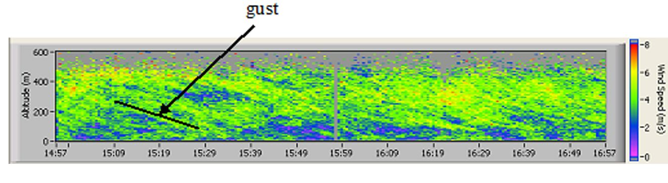
LiDAR: An example of a LiDAR image used to analyze atmospheric wind gusts to protect wind turbines. Image courtesy of NASA.
- 大數(shù)據(jù)管理系統(tǒng)
- 樂高機器人:WeDo編程與搭建指南
- 面向STEM的mBlock智能機器人創(chuàng)新課程
- Linux Mint System Administrator’s Beginner's Guide
- 21天學通Visual C++
- 網絡綜合布線設計與施工技術
- 傳感器與新聞
- PostgreSQL 10 Administration Cookbook
- 筆記本電腦維修90個精選實例
- Salesforce for Beginners
- Visual FoxPro程序設計
- 零起點學西門子S7-200 PLC
- 三菱FX/Q系列PLC工程實例詳解
- 大數(shù)據(jù)導論
- Building Google Cloud Platform Solutions