- Advanced Infrastructure Penetration Testing
- Chiheb Chebbi
- 111字
- 2021-06-24 19:12:53
Geospatial intelligence
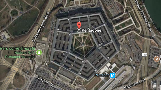
Geospatial intelligence (GEOINT) is the exploitation and analysis of imagery and geospatial information to describe, assess and visualize a defined area. The term GEOINT has become associated with information security and penetration testing. Identifying and collecting information about an organization will give penetration testers the ability to anticipate the physical intrusion of the organization. Thus, the role of a penetration tester is to make sure that data and sensitive information is safe from external threats.
There are many available sources to check for geospatial information. Google Maps is a free geospatial service provided by Google. The following is the result of a search, using a Google Map query:
推薦閱讀
- 電腦組裝與系統(tǒng)安裝
- Implementing Cisco UCS Solutions
- 從零開始寫Linux內(nèi)核:一書學(xué)透核心原理與實現(xiàn)
- 嵌入式實時操作系統(tǒng):RT-Thread設(shè)計與實現(xiàn)
- Dreamweaver CS5.5 Mobile and Web Development with HTML5,CSS3,and jQuery
- Windows 7實戰(zhàn)從入門到精通
- Introduction to R for Quantitative Finance
- Windows Vista終極技巧金典
- Advanced Infrastructure Penetration Testing
- Linux集群之美
- Windows 8完全自學(xué)手冊
- Angular權(quán)威教程
- Implementing Cloud Design Patterns for AWS(Second Edition)
- Docker for Developers
- Responsive Web Design by Example:Beginner's Guide(Second Edition)